This week MobiHealthNews covered the launch of a new mobile advertising network for healthcare providers, called Tomorrow Networks, that also has plans to target consumers using health apps with relevant advertising. Interestingly, the twist was that the ad network was only interested in apps that made use of a user's location, because, as Tomorrow Networks partner Physicians Interactive's President Sanjay Pingle told us: "Healthcare is still very local and advertising to consumers in a particular zip code or region will prove effective."
That got us thinking about how consumer health apps that leverage geolocation data to help users stay well, get well, or track their health. By our count there aren't too many substantial health apps available that make use of location yet.
Below are our picks for six GPS-enabled medical apps worth knowing about. Be sure to let us know which ones we missed in the comments section below.
iTriage
Designed and developed by two Denver-based ER doctors, iTriage aims to help consumers make better healthcare decisions by providing relevant medical info and access to local healthcare facilities. iTriage features a provider search function that leverages the iPhone's GPS or IP address location to find the nearest highly-regarded medical facilities and physicians, then gives users turn-by-turn directions. The newest version of the app includes over 1,000 medication listings, as well as an updated provider search function. iTriage currently has over three million downloads.
My Place History
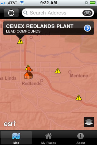
At the 2009 TEDMED conference, Bill Davenhall, who leads the health and human services marketing team at geographic information service ESRI, made the case that adding environmental data to patients’ charts — places the patients lived, types of chemicals and particulates found in those locations’ air -- could be important in improving patient care. Davenhall’s case rested on the hypothesis that living in some environments may predispose a person to certain diseases, so having a conversation about geography should be a part of a patient’s visit with their physician.
A friend of Davenhall’s allowed his location to be tracked every day for two years via his cell phone. Davenhall compiled the data and mapped his friends locations against those location’s environmental data — much of which is tracked by the National Institutes of Health. Davenhall used that test to develop My Place History, which uses public domain databases such as the Toxic Release Inventory (TRI) of the United States Environmental Protection Agency, and the National Institute of Health's known chemical database, to show hazards near the user's location.
Spiroscout
Spiroscout is a GPS and WiFi-enabled device that attaches to an inhaler and records the location and time of when medication was administered. User can then upload the data to a computer for later review. Lights on the device let you know when it has detected use, and also show remaining battery level. The device provides a much needed upgrade to the handwritten use-logs patients are supposed to be writing to help their doctors understand their condition. Additionally, epidemiologists will have more accurate data to analyze about asthma sufferers as well as GPS-based air quality trends. The device is an upgrade from Van Sickle’s 2009 device SilonSky GPS which required an extra box that users would have to carry around — now the GPS unit just sits right on top of the inhaler.
Allergy Alert
SDI's Allergy Alert is one of many allergy apps that displays the pollen and allergy forecast for a user's location, which is found via GPS. The app is integrated with the Ford SYNC with AppLink system and keep drivers aware of allergy, flu and asthma alerts in the areas they are driving through. You can control the app with your voice ("Allergy", "Pollen", "Flu" and so on) or with the radio preset buttons. SDI showed off the Allergy Alert app for the iPhone at an event held by Ford earlier this year focused on mHealth features in its vehicles.
Sickweather
Sickweather is an upcoming app, currently in beta, which plans to track illnesses that occur within a user’s circle of friends to help them stay well by avoiding contact with the infected. Sickweather taps into social networks like Twitter and Facebook to detect the presence of sick friends. The free service hopes to use an ad-supported business model to generate revenue. The site uses Twitter’s API to identify a user’s particular location, but the startup’s algorithm looks for keywords related to sickness such as “bronchitis,” pneumonia,” and “pertussis" and uses public information sources to see contagious illness affecting a certain area.
AED Locations
AED Locations allows users in New Zealand to locate the nearest AED (Automatic External Defibrillator) in an emergency situation using the iPhone's GPS. The app then uses Google Maps to give users directions to the AED. AED owners can also contribute their device's location to a country-wide database .
Want to read stories as soon as they are posted? Follow MobiHealthNews on Facebook.
On Twitter? Be sure to follow MobiHealthNews for up-to-the-minute news and industry analysis.


